On Wednesday myself and 2 hiking friends made the long drive north to Millionocket, Maine. Our plans were to spend a night at the Appalachian Trail Lodge, then drive to a parking area off Telos Road, and hike/xc ski ~5mi into Baxter State park on Williams Pond Road into a small 10×12 cabin called Camp Cozy located in Nesowadnehunk Campground area the following day. I decided to cross country ski the road, and my 2 friends made the hike in on snowshoes. We got to the cabin in short order, and soon had the stove fired up and made some lunch and gathered water from the nearby stream. The cabin is small, but the stove heated it quickly, and eventually we all went to sleep.
Our original plan was to make 2 hikes over the weekend, day one to North Brother and Fort, and the next day to Coe and South Brother. We awoke to light snowfall on Friday and started off hiking the Tote road down to the Marston Trail head. The ~3 miles went by fast and we signed in on the register, which had just a handful of entries this season. There had been a party of 4 just a few days earlier that had made an attempt but turned back due to very deep snow and we hoped to find some of the trail broken out, but the trail was blown over and covered in new snowfall. We broke trail in 6 or so inches of light snow up to the saddle, and made a left to ascend to North Brother. Winds picked up here and the snow became waist deep, making for very slow progress. At times it took 4 steps to move one, which is very tiring work. Luckily I was with 2 of the strongest hikers I know and eventually we made it to the icy top of North Brother. I was pretty gassed here but decided I would continue on to the trail-less Fort mountain. We picked a good line thanks to Pat’s planning, navigated through a small area of spruce traps, and soon found ourselves at the rocky highpoint.
Turning back the way we came, back up and over North Brother we returned to the saddle to decide our next move. We decided we would try the other 2 peaks on the itinerary, if we ran short of time at least we would get some trail breaking done for the next day. Our thought was we should hike out to Mount Coe first, as it was the longest leg, and we would hit South Brother, a short ~0.3 miles spur off the trail on our way back. Again we ran into some very deep snow, but slowly made it to the destination. The cloud cover afforded us no views. The sun was starting to go down around the time we made the summit of our 4th peak on the day, South Brother. We quickly put on headlamps and began the long hike out. I was running short on water at this point, and my legs were very tired, but there’s nothing one can do but put your head down and push on till you get down. We made good time back to the Marston Trail head, signed out, and began the seemingly endless ~3 mile road walk back to our camp. This bit seemed to take forever and I was running on fumes, thankfully Pat hikes fast and had the stove going when I got back.
None of us had the energy to make a real dinner so we just ate a bunch of snacks, guzzled some water, and got into our sleeping bags. This was the longest hike I’ve ever done, well over 20 miles, but I’m glad we did it all in one day, there’s no way I was going to hike all the way out there a 2nd day in a row. We all slept in Saturday and slowly packed up to hike out a day early. The XC ski in left me with a big blister, so I decided I would snowshoe out back to the cars. My legs still sore, it took 3+ hours to finally make it back to the cars, and we stopped for some food in East Millinocket. I have now hiked to the top of 85 of the New England 100 Highest peaks. What an adventure!
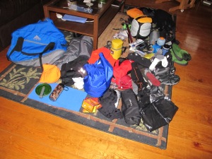
Pre trip planning
Ready to pull sleds ~5mi to camp
It’s a very nice camp
There sure is alot of snow!
Middle of nowhere
Sunrise at the Marston TH
Signing us in
Exhausted on peak 1/4 (North Brother)
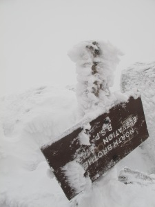
The sign is upside down and covered in rime ice
Top of Mt Fort
On Coe
On South Brother
Ready to pack out
Cleaning up the cabin
Total car-to-car stats:
Avg Moving Pace: 29:06 min/mi
| Elevation Gain: | 5,935 ft |
| Elevation Loss: | 5,937 ft |
| Min Elevation: | 1,056 ft |
| Max Elevation: | 4,126 ft |
| Distance: | 32.96 mi |
| Time: | 52:59:59 |
| Moving Time: | 15:59:12 |


