Buying Used & Hardly Used Gear on the Cheap

There are a number of ways to save big bucks buying gear, a new favorite site of mine is Gear Trade. GearTrade.com is the premier marketplace to sell and buy outdoor gear, and many of the items are not even used, they’re product returns to sites like Backcountry and others. I’ve racked up some significant savings there and you can sign up to unload some gear if you dont want it anymore.

Some of my other favorite spots to check are the REI 50% off outlet, REI Garage Sales, Sierra Trading Post (always google for coupons), and the GoLite Clearence Closet. Also, I tend to keep an eye on one deal a day sites like SteepandCheap.

Here’s how it works:

  • Steep and Cheap sells one screamin’ deal at a time until it’s gone.
  • The deals are fat, so they sell out fast.
  • You have to act fast or you’ll miss it, but don’t stress—as soon as one deal sells out, we kick off another.
  • It’s back-to-back deals all day long.

There’s always Ebay and Craigslist, as well as the LL Bean outlet if you are lucky enough to live near one! Have any to add?


At 10 ft. long, the Explorer Ultralite Asym Classic from Hennessy Hammock was designed for anyone under 250 lbs. or more than 6 ft. tall-you get more comfort without the weight.

Control Towers

Trip Report: The Belknap Range – Mt. Piper, Mt. Belknap, and Mt. Gunstock

On Saturday I joined a group for a hike in the Belknap Range of New Hampshire. I have been to Mt. Belknap once before, but this trip brought me to two new peaks, Mt. Piper (North peak) and Mt Gunstock. Our hike started at the gate on Belknap Mountain Road in Gilford. From here we ascended the red trail up to the summit of Piper. On a clear day there are some nice views here, but it was cloudy when we got up there. An interesting feature of the Piper summit is all the random rock furniture that people have built there:

IMG_0265

IMG_0266

IMG_0269

From here we took the orange trail to the white trail toward Mt Belknap. We had noticed the trail was a bit of a mess here from people bare booting when they should have worn snowshoes. At the junction of Orange and White trails we put ours on to flatten things out, they remained on the rest of the way.

IMG_0271

WE reached Mt Belknap in short time and sat down under the fire tower to have some lunch, and were soon off on the Blue trail towards Mt Gunstock. On this stretch we met our only other hiker of the day, a gentleman and his dog. They must of had some difficulty that day without snowshoes and seemed excited to see our group of 6 with them on. There was lots of people out enjoying the skiing atop Mt. Gunstock, I always find it fun to ascend a ski mountain in winter. Avoiding the temptation to visit the pub on the summit, we followed the white trai which goes to the left of the safety services building. This is not obvious at all and I was glad someone in our group knew it, as there are not any markings at all. The White trail drops steeply and then levels out to from very nice woods, the snow was falling here but there was no wind and it was very pleasant. Before we knew it we were back at the cars and off to find some dinner, a great day of winter hiking!

IMG_0276

IMG_0275 IMG_0274

For a map of the area see the this post

GPS/GPX Link

Distance: 4.76 mi
Time: 4:32:25
Avg Pace: 57:16 min/mi
Elevation Gain: 1,740 ft

Gear Review: Big Agnes Three Wire Bivy Sack

This was my second test of the Big Agnes Three Wire Bivy Sack, my first time ever sleeping in it during a blizzard. Friday night called for somewhere between 18-24 inches of snowfall and blizzard conditions. I decided it would be the ultimate test of this emergency shelter as well as some other cold weather gear I wanted to try close to home before venturing out into the mountains. I made the long trek into the back yard with the Big Agnes Three Wire Bivy Sack, a 8×10 blue tarp, my LL Bean Mount Washington -20 degree sleeping bag, and my Therm-a-rest All season sleeping pad. It was snowing about 1-2 in an hour, but I got the shelter setup very quickly and settled down for the night. I woke just a few times, and used my feet to kick the roof of the shelter lightly to remove any snow that had piled up. Around 6, after what I must admit was some really good quality sleep, the sun started coming up so I convinced myself it was time to head back in. A solid 24 inches of snow fell, but I wasn’t cold at all. Even better, there was not any condensation on me, my sleeping bag, or the bivy. Opening the door I came to find that although I had setup on flat ground, I was now encased in the new snowfall, which insulated me quite well! The bivy is very easy to setup once you have the hang of it, and at 1.2 pounds, it is very light weight. I can personally attest to it being Blizzard Proof! I only have some shoddy cell phone pics but here they are:


Big Agnes Three Wire Bivy Sack

bivyclosed

Big Agnes Three Wire Bivy Sack 1 person, light weight solo shelter.

 Beforebivy4

After!

bivy2

bivy3

bivy1

Trip Report: Glocester Land Trust – Steere Hill & Phillips Farm

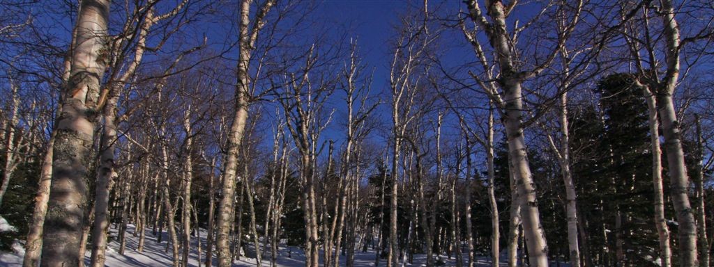
I’ve been unsuccessful with finding any shed deer antler this year, so Saturday I ventured out to some local trails to try again. With no snow cover I thought I might have better luck, and these area does not allow hunting which is always a plus. I did about 50% of the time off trail, which was very nice and easy going. The woods were open and not very thick at all. There is quite a bit of interesting rock ledges in this area. Eventually it opens up to a field with a bit of a view, I spent a lot of time wandering around here, but still, no luck shed hunting. All the trails I did take were very well marked and maintained, this is some of the finest hiking Rhode Island has to offer.


Distance: 4.66 mi
Time: 2:32:56
Avg Pace: 32:49 min/mi
Avg Speed: 1.8 mph
Elevation Gain: 369 ft


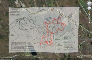
They have a handy trail map available online:

Via the GLT website:

Steere Hill & Phillips Farm

Overview/History – The Steere Hill Conservation Area is comprised of four abutting parcels acquired from 1967 to 2010 with a total of 448 acres. The 68 acre Phillips Farm was the first property acquired by the GLT in 1990. Before the 1920’s this farm was the Cutler Farm and the site of the historic Cutler Inn and Tollbooth.

West of Phillips Farm is the 208 acre Steere Hill Conservation Area acquired in 2002. During the early 20th Century, both Phillips Farm and Steere Hill were used for orchards, hayfields, woodlots, and livestock. The northern portion of Steere Hill was Angell’s Farm until 1959 and remnants of farm buildings and silos are still visible at the parking area. The summit of Steere Hill was a large apple, pear and peach orchard operated by the Steere’s until 1963. Recently on Phillips Farm and the summit of Steere Hill the GLT has created a 26 acre wildlife habitat of tall native grasses for threatened ground nesting birds such as woodcocks and bobolinks.

West of Steere Hill is Heritage Park, a 115 acres woodland acquired by the Town of Glocester in 1967 as part of the state’s Green Acres program. South of Heritage Park is the 57 acre LePlat Woodland acquired by the GLT in 2010.

There are six miles of marked and maintained trails that connect these properties.

Directions: These properties are in the Harmony village area and two parking areas with trailheads are available. The parking area for Heritage Park is on Chestnut Oak Road, and the Steere Hill parking area is opposite the Harmony Post Office on Putnam Pike (Route 44).

Overlay trail map to my GPS track

steer

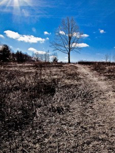
Nice tree in the open field

steer2

I am guessing a hawk took off with a rabbit here?

steer3

Fun in the swamp

steer4